Unveiling the Power of Drone Imagery
Transforming Perspectives with Aerial Insights
Unlocking Transparency, Efficiency, and Savings Across Key Scenarios
By the Numbers
| Scenario | Traditional Cost | Drone Cost | Annual Savings |
|---|---|---|---|
| City storytelling | $15,000–$25,000 per project | $1,000–$2,500 | $12K+ per project |
| Construction progress | $3,000–$5,000/month | $800–$1,200/month | $24K–$46K/year |
| Asset inspection | $5,000–$50,000 per site | $500–$2,000 per site | 70–90% per asset |
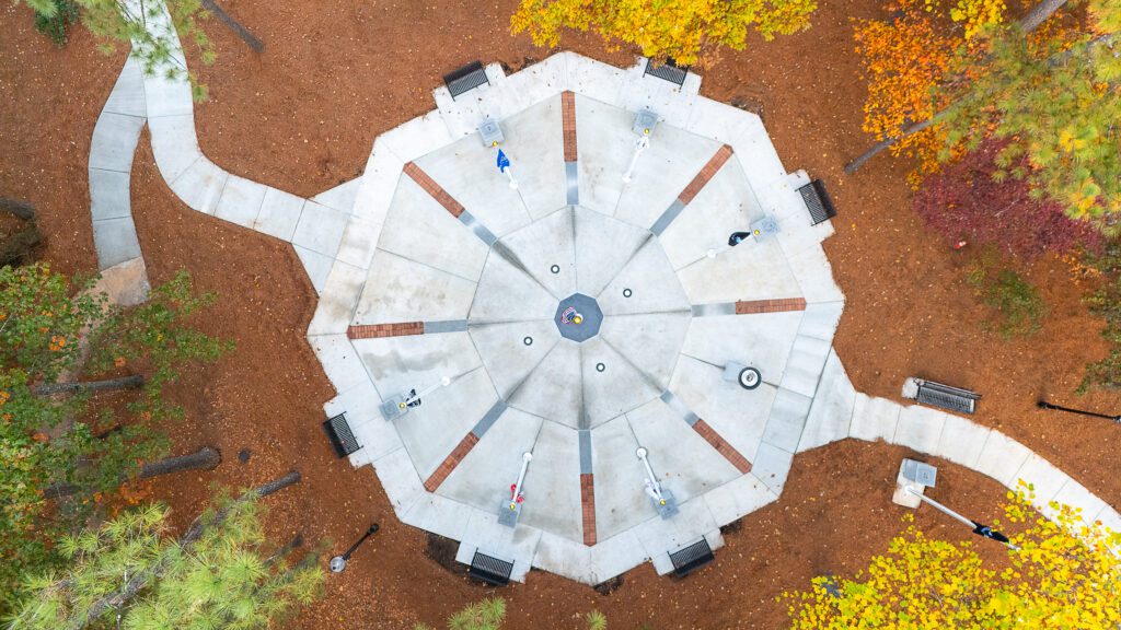
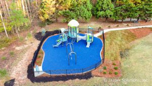
Enhancing Community Engagement
Drone Imagery: A New Lens on Public Spending
The Challenge
Citizens want transparency. A line item budget spreadsheet rarely satisfies the question, “What did my money actually build?” Traditional methods, static before and after photos, lengthy council presentations, or expensive video crews, leave gaps in the narrative.
The Drone Solution
A drone flight can produce
- Time Lapse Video of a new park, memorial or infrastructure project from groundbreaking to ribbon cutting.
- Hyperlapsed Photos showing stop motion build activity that makes for engaging social content.
- Orthomosaic or 2D Maps that highlight new sidewalks, lighting, and playgrounds. The imagery can be time lapsed to show progress over the course of the project.
- Panoramic or 360 degree imagery providing virtual tours which can be posted on social media, embedded in city websites, or shared via QR codes on site signage.
Real World Payoff
- Engagement Spikes: Swapping stock photos or ground level cell phone snaps for an aerial view or dynamic panoramic increases the public engagement.
- Trust Builds: Visual proof of progress supports the narrative and master plan, reducing community skepticism and increasing support for future initiatives.
- Cost Savings: A $1,200 drone shoot replaces a $12,000 helicopter rental and a $5,000 video crew to capture similar imagery.
Drone imagery provides local governments with a powerful tool to visually communicate the allocation of taxpayer dollars. By offering a bird’s-eye view of ongoing projects, communities can see firsthand the progress and impact of public investments. This transparency fosters trust and encourages informed dialogue between citizens and their government. Drone storytelling turns abstract dollars into concrete results and strengthens community support for the next project.
Case Study
City of Phoenix, Arizona’s Drone Program for Public Transparency and Communication: The City of Phoenix launched its multi-department drone program in 2022, with expansions through 2024. The Communications Office, joining in January 2024, uses drones for proactive videography, including “beauty shots,” construction progress tracking, and promotional footage—forecasting about two flights per month in 2025. This helps showcase infrastructure projects and community enhancements, turning taxpayer investments into visual stories shared publicly. For transparency, the city publishes flight-level data, policies, and metrics on a public website and open-data portal, including purposes, timings, and outcomes like reduced response times. Drones enhance community understanding of public safety and development efforts, reducing skepticism and demonstrating efficient use of funds—outpacing satellite’s limitations in on-demand, high-res detail.
Transform Your Storytelling
Experience the power of visual storytelling with our state-of-the-art drone services. Capture breathtaking aerial shots that elevate your narrative and engage your audience like never before.
Enhancing Construction Monitoring
Construction Perspectives on Drone Utilization
Maximizing Project Oversight with Drone Technology
Construction Company Perspective
Superintendents juggle subcontractors, weather delays, and change orders. Weekly ground photos miss overhead conflicts, and daily site walks eat billable hours.
The Drone Advantage
- Daily or Weekly Orthomosaics (georeferenced, to scale) overlay directly onto BIM models for clear visibility of construction progress and alignment to plan.
- Volumetric stockpile calculations that eliminate disputes with providers.
- Safety documentation showing site conditions – proof that fall protection netting was installed before the inspector arrived.
- Liability protection – show site conditions as they evolve and avoid liability with visual proof.
- AI Analysis – drone imagery can be processed by AI engines to detect defects, safety hazards, and design misalignments.
Owner / Client Perspective
Owners write the checks but rarely set foot on site. The monthly PDF reports convey numbers and a written status, while the true picture remains abstract and elusive.
The Drone Advantage
- Milestone Proof – 4K photo evidence of completed milestones.
- Executive Dashboards – enhance monthly reporting with progress videos, and dynamic panoramics that clearly show the state of the project.
- Change Order Validation – visual evidence that extra concrete was poured.
- Insurance & Bonding Audits – streamlined with timestamped, geotagged media.
- Maintenance / Repair – visual evidence that rebar was installed correctly before the concrete pour, and know exactly where the conduit is located.
Case Study
Brasfield & Gorrie’s Tower Project Optimization: Brasfield & Gorrie, a leading U.S. contractor, integrated DroneDeploy on a high-rise tower site, generating 3D point clouds overlaid with BIM models. Weekly drone flights reduced survey times from 2–3 weeks to under four days on a 60-acre site, spotting earthwork discrepancies that saved $150,000 in rework. The detailed imagery revealed individual studs and powerlines, enabling precise subcontractor coordination—capabilities satellites couldn’t match due to resolution limits.
Revolutionize Your Project Tracking
Discover how drone imagery is reshaping the landscape of construction progress reporting, providing unparalleled accuracy and efficiency.
Asset Inspection Revolution
Drone Imagery for Maintenance Planning
The Challenge
Rooftops, towers, bridges, and solar farms are expensive and dangerous to inspect with cherry pickers, scaffolding, or helicopters.
The Drone Advantage
- Automated Flight Paths – capture every inch in 4K and/or thermal.
- AI Analysis – defect detection that flags cracks, corrosion, or vegetation encroachment.
- Digital Twin – 2D geotagged maps and 3D models for timelapsed analysis to determine wear and tear.
Safety Bonus
Zero workers at height = zero OSHA reports from inspection activities
Case Study
Bilfinger’s Industrial Asset Corrosion Scans: Bilfinger, a global maintenance firm, deployed Voliro T drones with ultrasonic probes on over 400 high-temp industrial assets (e.g., flare stacks up to 260°C). Thermal and UT data detected corrosion early, averting shutdowns and saving clients 24 days of labor plus $165,000 per campaign. Drone’s contact-based inspections provided NDT-level precision without scaffolding—reducing costs 70–90% vs. traditional methods, while satellites offered no thermal or oblique views for such targeted diagnostics.
Unlock the Power of Aerial Insights
Drone imagery isn’t a line item expense. It’s an investment in clarity, speed, and risk reduction. Whether you’re a mayor proving fiscal responsibility, a GC protecting profit margins, an owner safeguarding capital, or a facilities team dodging six-figure repairs, the question isn’t “Can we afford drones?” It’s “Can we afford to keep operating blind?” Contact us, a Part 107-certified drone service provider, for a no-obligation consultation. Your taxpayers, stakeholders, and bottom line will thank you.